I awoke very early and drove the RV for a few hours before Emma woke up.We were in the high Chihuahuan desert at about 4,000 feet as we sailed across New Mexico headed for Las Cruses.


I spotted this cooperative Sage Thrasher in Las Cruces while Emma was working on some Red Fox
files for her society. We continued east over the mountains to White Sands National Monument. This took us through the White Sands Missile Range but there was no action on this day.

White Sands National Monument is the largest area of gypsum sand dunes in the world. The sand is pure white and very fine. It gets into everything. The dunes build up to 30 feet high and are constantly moving.


We went for a nature walk through the dunes and Sona got down with the dunes. She was playing in it like it was snow except she kept getting a mouth full of sand.


The desert plants have adapted to the moving dunes and use three basic strategies to thrive in this shifting desert.


February 1
We drove south into into Texas. The driving around El Paso was even crazier than I remembered. Cars are moving at 70 mph with 3 feet between vehicles. To change lanes, drivers dive into spaces ten feet wide. Emma was loudly and rapidly assigning blame as we charged through this crazy sprawling city with its insane drivers. I must admit I got a demerit point or two from Emma as we cruised along.
We left highway 10 and took a quiet side road to Davis Mountain State Park. The empty open road was a refreshing change to the insanity of city driving.

The landscape changed from high Chihuahuan desert with its statuesque yuccas to more rolling prairie then junipers as we rose into Davis Mountain.

February 2
When we awoke in the Davis Mountains there were 112) Eastern Bluebirds feeding beside the RV. It was time for exercise so we went on a nice morning hike up skyline trail. It was just the kind of hike Emma likes, straight up. I was huffing and puffing in no time.


They call it skyline trail for a reason as the views were spectacular.


Javelina rarely attack people but have been known to swarm and kill dogs if they feel threatened. We quickly jogged down the trail to our camp site.
In the afternoon, I went on a bird watching walk while Emma and Sona had a walk near our camp site. I saw:


115) Blue-grey Gnatcatcher
Emma had more fun than me on her walk. As she and Sona circled the campground they encountered several javelinas in front of them. Turning around they were confronted by several javelinas behind them. One male stepped forward and raised the hairs on its back in agitation and aggression. Emma and Sona beat a sideways retreat.
I missed a real photo opportunity there. Emma saw it differently.
February 3
We drove down to nearby Fort Davis which was established in the mid 1800s to guard part of the only all-season trail to California.

In a losing battle against American "manifest destiny", the Comanche and Apache defended their territory against the Mexicans and Americans for more than 100 years.

We drove into Big Bend National Park.

The high dry Chihuahuan Desert makes up most of this expansive park. It is a beautiful and remote part of Texas.


We drove through the main park headquarters at Panther Junction and down to Rio Grande Village for the night.


February 4
There were lots of birds along the banks of the Rio Grande River. during our morning walk we saw:


Javelina

We did a hike along the banks of the Rio Grande river to the hot springs 5 kilometres away. The views of the river and into Mexico were spectacular.


Along the way we saw a rather playful Rock Wren hopping among the rocks and cacti.


Near Rio Grande Village, the canyon opens up into a wider valley. The village itself is rather small. It consists of no houses, one store with gas pump, and and two campgrounds.
In the afternoon, we took the nature walk at the second campground. This walk goes through a small marsh to a ford across the Rio Grande.


As we approached the Rio Grande, a Mexican on horseback was sitting on the far bank. Local Mexicans cross the river to trade trinkets for cash. This is illegal but it looked like he had a fast horse. If the border patrol showed up he could quickly gallop back over the Rio Grande.


January 5
We left Rio Grande Village and went for a hike at Boquillas Canyon on the Rio Grande.

On the Mexican side, a fellow was high up on the cliff singing away. His partner was in a row boat on the US shore. "Singing Victor" crooned away as I chatted with his partner. They used to run a row boat ferry service across the border. They rowed people across then gave them a donkey ride up to a nearby restaurant. Now that the border has tightened up, they sing for donations and slip across the border to trade trinkets.


We left the Rio Grande and traveled into the middle of the park, then up into the Chisos Mountains.


The road up to Chisos Basin is recommended for RVs under 24 feet so it was a tight squeeze on some of the turns with our 27- foot RV. We crested Panther Pass and dropped down into the high mountain valley called Chisos Basin.

Casa Grande Mountain rises above the warm fresh air of Chisos Basin.


February 6
We woke early and at 7:30 a.m. we were the first hikers up the Lost Mine Summit Trail. This hike was a constant up-hill grind through spectacular open oak forest.


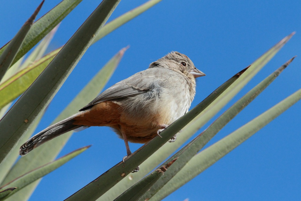
Near the top of the trail, we encountered a couple of 118) Black-chinned Sparrows. I've been hoping to see this bird for quite some time.


From the top of the peak you can see the aptly named rock formation called " The Window".
T
View down Chisos Basin to The Window
We completed the Lost Mines Trail at noon. Emma was tuckered and went for an afternoon nap with Sona. I decided to check out the trail to the Window.

From Chisos basin, the Window descends to a viewpoint of the surrounding desert below.

I started out on the hiking trail and quickly encountered the standard cautionary sign.

I didn't give it a second thought until I encountered a second more specific sign which read:
Danger mountain lion country keep children close and move in groups. I rationalized that I was in a group of three, .... me, myself and I, so onward I went.
A third sign definitely got my attention as it read:
"Extreme Danger, Aggressive Mountain Lion in the Area".
I should have taken a picture of that sign as you don't see a sign like that too often. However, I was too busy packing my camera away so that I could carry my bear spray in one hand and my hunting knife in the other. As I continued, my imagination got the best of me and I was anticipating an ambush around every corner.
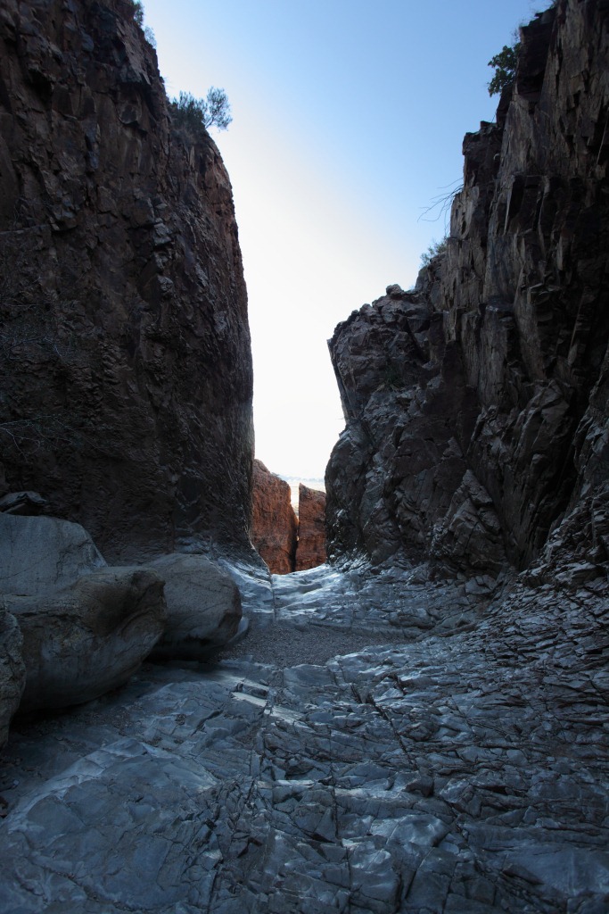
The Chisos Basin narrowed and became a steep narrow canyon as I approached " the window". I retrieved my camera from my backpack to record this amazing window into the desert below.


It was late afternoon when I ascended back to our campground. We were both happy. Emma was refreshed from her afternoon nap and I was alive.

Emma whipped up a batch of gluten free flap jacks to celebrate.

February 7
To complete our tour of Big Bend, we descended from the Chisos Basin and headed to the west side of this National Park. Along the way we saw some interesting rock formations


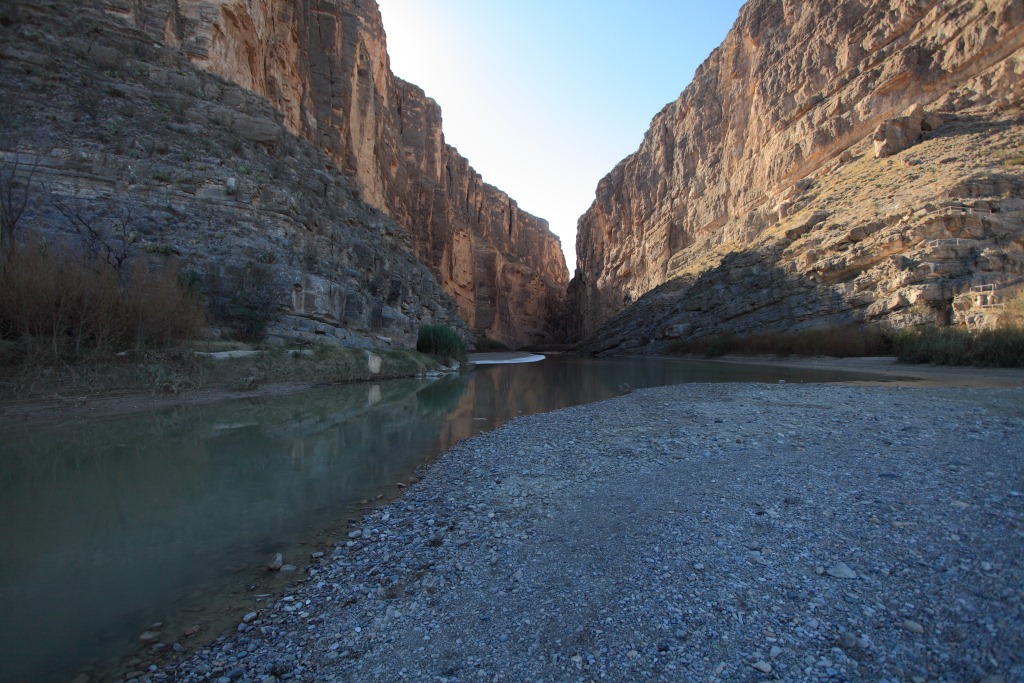
Rio Grande River emerging from Elena Canyon


Elena Canyon


The walk through Elena Canyon was exhilarating. The Rio Grande was a tranquil, slow-moving stream that you could wade across to get to Mexico. Yet over the years it carved a canyon hundreds of feet deep.
It was time to leave Big Bend National Park, so we packed up and headed for the town of Marathon. This park had one more surprise as the way out of the park was through a small gap in a continuous mountain range.
