It was another hot sunny day as our RV climbed up to 6,000 feet through rolling pine forests. It was a short drive to reach Yosemite National Park but all roads into the Sierra Nevada take time.
However, the views just get better and better as you approach the mountains. It was still early in the year so the snow-capped peaks were complemented by the water-filled creeks and waterfalls flowing down the mountainsides.

We rounded a non-descript corner and entered a tunnel. On the other side was the iconic view of Yosemite Valley with El Capitan on the left and Half Dome on the right.

Entrance to Yosemite Valley
It is a view that just takes your breath away.

Half Dome

Emma was impressed

Sonaa not so much. However, there were lots of people there so she went into her pet me routine.
Many people have to leave their dogs at home when they travel and Sonaa steps in as a surrogate.
Moving into the mouth of the Yosemite Valley we stopped near El Capitan.


El Capitan is a 3,000 foot vertical granite monolith and world famous as one of the very best rock climbing sites in the world.

El Capitan
If you look closely you can see climbers working their way up El Capitan along famous climbing routes like The Nose and Astroman.

Summit of El Capitan
Of course, it's easier to spot the climbers if you have a big telephoto lens

Rock Climber on El Capitan
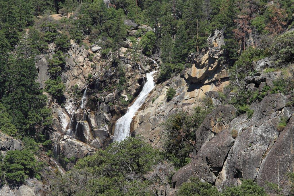
It was a busy day in Yosemite Valley and parking was at a premium, particularly for RVs. We spotted a decent spot by Bridalveil Falls and pulled in.

It was a short half mile walk to scenic Bridalveil Falls.

Bridalveil Falls


Mist rolled off the top of Bridalveil Falls. Perhaps that is how it got its name.

Bridalveil Falls
It was impressive to see all the waterfalls cascading into Yosemite Valley. We were fortunate to be here in late spring as the waterfalls usually dry up by August.

As we wandered around Yosemite Valley we were constantly surprised by the array of fascinating rock peaks overlooking the valley. John Muir did some of his best work when he helped protect this valley and got it designated as a National Park.

We drove further into Yosemite Valley and parked near Yosemite Falls.

Yosemite Falls is one of the tallest in the world. It is actually made up of three separate falls: Upper Yosemite Falls (1,420 feet), middle cascades (675 feet) and Lower Yosemite Falls (320 feet).

Upper Yosemite Falls

Cascades and Lower Yosemite Falls

California Ground Squirrel
California Ground Squirrels were ubiquitous throughout the valley. They have become accustomed to the flow of people along the trails and continue about their foraging activity despite the crowds of people passing by.


Emma and Sonaa walking to Lower Yosemite Falls.
The traffic on the paths suited Sonaa just fine. As Emma and I enjoyed the sights Sonaa worked the crowd for a record number of pats and belly rubs.


Lower Yosemite Falls

Lower Yosemite Falls

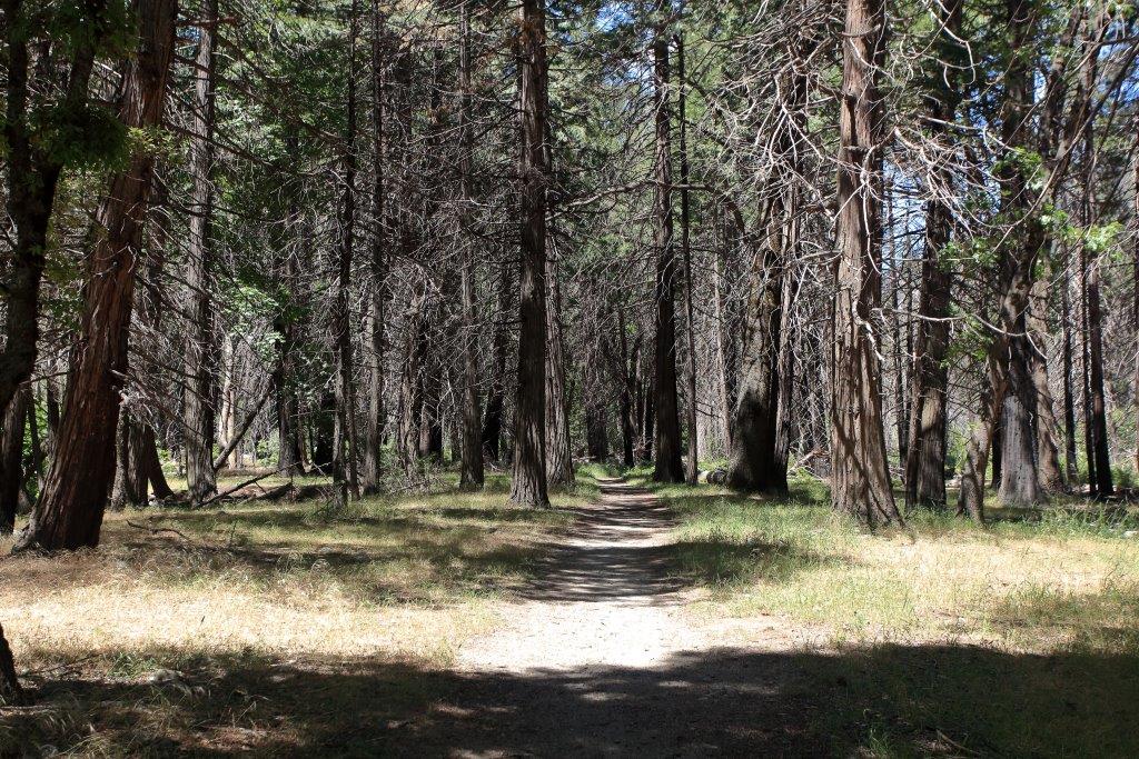
We continued our tour through Yosemite Valley and headed toward Yosemite Village. It was a hot day but the forest paths and hiking trails were nicely shaded by giant pine trees.


California Ground Squirrel
Ground squirrels and deer were foraging just off the paths. Typically wildlife goes to an alert posture when humans appear and you can get a nice engaging photograph if you are quick. However, here the deer were so habituated to humans that they continued browsing and rarely raised their heads to glance about.

Mule Deer

Yosemite Museum
Yosemite Village consists of a few rustic public buildings with vintage masonry from the 1930s. It was good to see that beyond the historic strucutres there were few additional buildings inside this beautiful national park.

We wrapped up our Yosemite Valley visit for the day with a walk through the central meadow of the
valley.


Half Dome

Emma at the meadow in Yosemite Valley
What a great day! We headed back to our Yosemite Pines RV campsite trying to comprehend the incredible physical beauty we had experienced.
I took the wrong turn heading back to our campsite so saw more of Yosemite National Park than we had planned. By the time we got back to our campsite near Groveland, we were running low on gas.
Luckily, I spotted an old dilapidated gas station with pumps that had to be more than 70 years old. There was an opening and barely enough room for our RV so I zoomed into the open pump with inches to spare.
The locals kind of stood there open-mouthed for a few seconds, both impressed and shocked that I was able to fit my RV alongside the pumps. Recovering, a local stepped up and told us to go three miles down the road as these heritage pumps had not been in working order for 50 years.
June 18
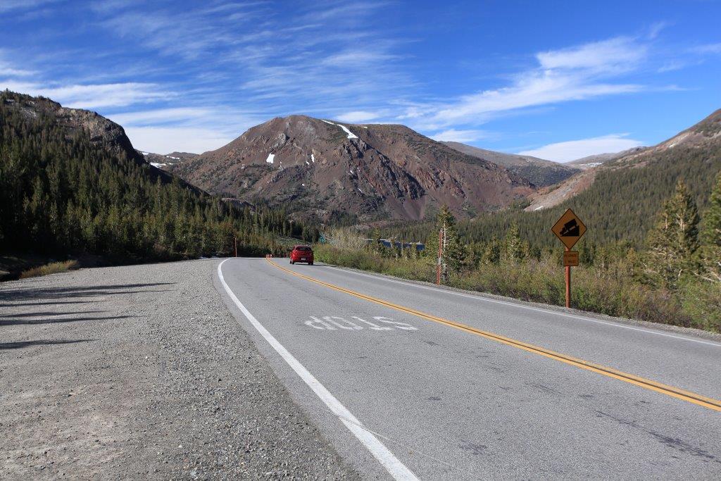
It was a warm and sunny Saturday morning and getting hotter by the minute. We decided to drive back into Yosemite National Park and take the Tioga Road up and over the Sierra Nevada to Mono Lake. It is the only road through the Sierra Nevadas for hundreds of miles in either direction and, due to heavy snowfall, it is usually open late May through October. Taking this route would give us another perspective of the park and would avoid Yosemite Valley on the weekend.

Good choice. As we entered the park we were informed that there was a four hour traffic jam of cars waiting to get into Yosemite Valley. We took the Big Oaks Flat Road to connect with the Tioga Road then continued into the high country.

Pine forests predominated with snow-capped mountains on both sides of the road.


A colourful array of wild flowers were blooming through cracks in the rocky terrain.

Pussypaws (Cistanthe monosperma)

Pussypaws - detail
Most decaying snags had several woodpecker holes. Here the dominant species was the White-headed Woodpecker and seeing one would be a first for me.


Several species of flowers were in full bloom and covered the rocks with a cascade of colour.

Mountain Pride - (Penstemon newberryi)
After traveling half way across the Sierra Nevada we stopped at Olmsted Point to take in the view and do a short hike.

Emma and Sonaa with Clouds Rest on the far left and Half Dome in the middle distance

View of Half Dome from Olmsted Viewpoint

Going up and around Yosemite Valley on the Tioga Road provided a new perspective on some familiar Yosemite landmarks. From Olmsted Point, you got a back door perspective on Half Dome.

Half Dome from Olmsted Point

Emma and Sonaa enjoying Olmsted Point. Emma enjoyed the views and Sonaa enjoyed considerable success panhandling for pats.

Tenaya Lake viewed from Olmsted Point

It was impressive how pine trees can survive extensive fire and decay damage to the base of their trunks and still continued to thrive.


Walk to Tenaya Lake

Tenaya Lake
We continued on to Tenaya Lake and did a short hike along the lake shore. The water level was high and washed out the trail on the west side of the lake. Rather than wading barefoot through the shallows we decided to do other hikes at higher altitude.

Moving east we arrived at the Tuolumne Meadows. This sub-alpine meadow was an important ecosystem of the high Sierra Mountains. The sweeping vistas of the surrounding mountains was equally impressive.

Winding through the meadow was the pristine Toulumne River. As we walked beside this mountain stream we saw a herd of Mule Deer browsing on the far side of the meadow.

Toulumne River
Continuing further east we arrived at Tioga pass by the east entrance to Yosemite National Park. At 9,945 feet, this pass was the highest in the park.

Much to Sonaa's liking, there were large snow patches beside the road.


Unique tree beside the Tioga Peak trail.
We took the three mile round trip Tioga Peak trail. It started by the entrance station at Tioga Pass and wound steadily uphill to the peak. There were large patches of snow on the ground but they were easy to navigate.

This was a great hike.You start at 10,000 feet and quickly rise into an open alpine ecosystem as you approach Tioga Peak.


Tioga Peak

Emma looking for Gray-crowned Rosyfinches
The panoramic mountain views from Tioga Peak were absolutely magnificent.


We were alone at the top of the mountain. It was a glorious day and we took time to marvel at the beauty around us in every direction.


Too soon it was time to head back down the trail.

We fired up the RV and descended along the east side of the Sierra Nevadas.
Tioga Road heading down through the pass

Near the top of Tioga Pass, you could see the gap in the Sierra Nevadas that led down into the desert-like terrain by Mono Lake.

With a little luck and some solid bridge construction, we finished the day south of Mono Lake at a small RV campground on Grant Lake.
No comments:
Post a Comment