It was a cool, drizzly day as we drove the 300 kms from Denali to Fairbanks. By the time we reached Fairbanks, the sun had broken through the clouds as we parked by the visitors centre. There was a scenic walkway along the Chena River so we had a leisurely late afternoon stroll and admired many small sculptures and displays. Emma was particularly enamoured with the pretty orange bicycles that the city provided.

Emma is always happy when she can have a bike ride.
July 6 and 7We liked the genuine small town feel of Fairbanks and spent two days wandering around. Similar to Anchorage, most of the commercial buildings were one or two storeys and the few tall buildings were only six to eight storeys.
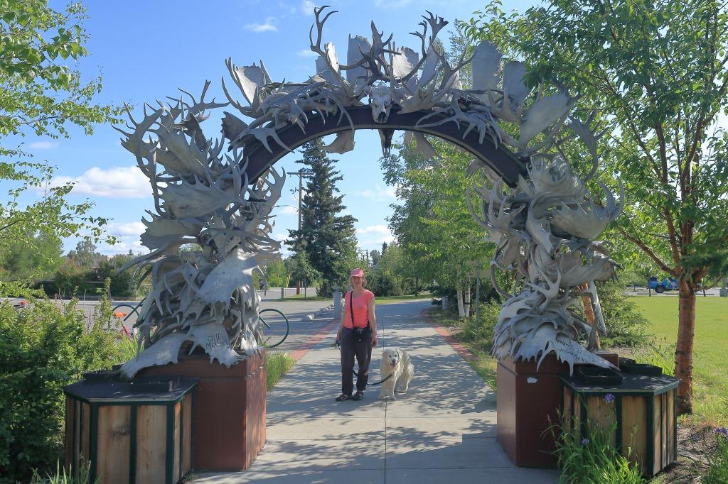
Antler Arch
Unlike the elk antler arch in Jackson Hole, Wyoming, the Fairbanks arch consisted of moose and caribou antlers.Our walks were fun because the weather was sunny and warm, all the flowers were in bloom, and the people were laid-back and friendly. We did a lot of walking both along the riverbank and through the 44 acres of Pioneer Park. The history and art of Alaska were prominently displayed and celebrated. We soaked up the congenial atmosphere.
"Summertime and the living is easy."

On our last day in Fairbanks, we drove to the bird sanctuary at Creamers Field. Back in the 70s, it was a dairy but more recently it was converted to a bird sanctuary. The usual bird suspects were hopping about, but no rare bird sightings were made on this day.

Dark-eyed Junco - Slate-coloured subspecies
July 8
Time to complete our road circuit of Alaska, so we headed east under overcast skies. Near Delta Junction, we intersected with the 1,200 km Trans Alaska Pipeline as it wound its way from Prudo Bay to Valdez.

Alaska Pipeline
As we took pictures of the pipeline, we drew the attention of a security crew who followed us about to make sure all we were doing was taking pictures.
We had miles to go but almost called it a day at Delta Junction because of wind warnings and the fact that the gusts were rocking the RV sideways as we sped along. However, the wind storm was just starting and we figured correctly that the approaching mountains would soon shield us from the worst of the wind. Still it was a tense hour or two as I gripped the rocking RV steering wheel while calmly reassuring Emma not to jump out of the RV.

Gerstle River Rest Stop
After several hours of hard driving along the Alaska Highway, we stopped to stretch our legs beside the expansive Gerstle River. By midsummer, the river was fairly narrow but the flood plain around it was expansive. Spring run-off would be impressive to see.
Refreshed, we motored on to Tok then hung a left and headed north to Chicken, Alaska.

North of the Alaska Highway, you are in the out-back of the North American continent. The terrain was wide open and wild. There was nothing but miles and miles of miles and miles. It was beautiful.

Willow Ptarmigan

The blue hour in northern Alaska
As the sun set we arrived at the tiny mining village of Chicken. In its goldrush heyday, it was a bustling frontier mining town but now it is a small tourist rest stop with rusting mining equipment strewn about.

Welcome to Chicken, Alaska
Back in the day, the miners wanted to name the town Ptarmigan after the plentiful Willow Ptarmigan that are still here today. Unfortunately, the miners could not agree on the spelling of Ptarmigan. Not wanting their mail to get lost in transit, the miners settled on a name they knew everyone could spell. Chicken, Alaska was born.
July 9
Our morning started with a walking tour around the shops and old mining equipment in Chicken.
My daughter was a dedicated chicken fan and had requested a few items from this small but famous venue. Several hats and T-shirts later, we headed east following the Forty Mile river.
44) Saye's Phoebe

Forty Mile River
We stopped for lunch at the campground beside the river, and tried a little gold panning in the stream.
Not our day to find gold but it was fun splashing about in the river all the same.

Northern Tundra
You really do feel like you are on top of the world as the rolling tundra unfolds for miles around you. The rough gravel road sections limited our speed to a pedestrian 10 kms an hour, so we really got to take in the gorgeous view as we ambled along. Any faster than walking speed and the RV would have shaken apart.

"Hi Lucy, should we let the tourists pass"
We inched along the road as it followed the Forty Mile River across the tundra. Suddenly, there were caribou everywhere, to the left of the road, to the right of the road, and all over the road.

Not only had we found the world famous "Forty Mile Caribou Herd", we were right in the middle of it. This stretch of the Forty Mile River was their primary calving ground and baby caribou and their mothers were everywhere.

We were watching them. They were watching us. It was quite the spectacle.

The once gigantic Forty Mile caribou herd had been in sharp decline for decades and had been in danger of disappearing. However, through thoughtful conservation over the past 20 years, it had been on the comeback and was starting to reclaim its territory and former size.

There were caribou from the road's edge to the horizon

Mom and Calf

Mom

Calf

The idyllic setting lent itself to a stroll on the tundra, so we pulled over and hiked up to a little hillside kern. There was neither man nor beast, except us, to observe this glorious view of nature.

Kern at the top of a small hill in the open tundra.

On this warm summer day, we marvelled at the expansive vista without a tree or creature for miles.

Suddenly, hundreds of caribou popped out of nowhere just a few dozen metres away.
They saw us and swiftly glided around a small hill and out of sight.

Quick as a flash, I grabbed my long lens and ran around the other side of the hill to cut them off.
I rounded the small hill and . . . . nothing. They had disappeared off the face of the earth. Despite almost no cover, a thousand caribou had vanished.
Back to Emma and Sonaa I wandered, while scratching my head. Where had that massive herd of caribou gone. Looking up, I saw Emma crouched down and almost cowering over top of Sonaa. Emma was usually large and in charge so this was a surprise. Getting closer I saw a mask of fear on Emma's face.

I spun round and there were the thousand caribou slowly advancing on Emma and Sonaa "the wolf". The male caribou were in front with their antlers down. I had inadvertently cut off their earlier retreat and they had doubled back only to be thwarted from freedom by a small wolf and a woman. They were in the process of removing that impediment.
I had missed the charging grizzly bear earlier in our trip and was not about to miss photographing this confrontation. Throwing caution to the wind I stood tall and whipped up my long lens.
At the sight of the Cannon long lens coming to bear, the caribou herd wheeled as one and thundered off in their original direction.

Emma, Sonaa and I beat a hasty retreat in case the herd changed its mind.


Two lone caribou watched our departure.

We stayed in the RV for the rest of the trip and, by late afternoon, we were approaching the Yukon River near Dawson City.
The ferry ride across the Yukon River was free compliments of the territorial government.

Historic Paddlewheeler, the SS Keno
The slowly setting arctic sun shone a golden glow over this picturesque historic town.
At the end of the 19th century, this place was a bustling goldrush town of 40,000 people.
The historic buildings and wooden sidewalks have been preserved to create a snap shot into life in an earlier century.

Dawson still had the feel of a rough and ready semi-lawless town

Okay not that rough and ready. I'm pretty sure they were joking about the parking regulations so decided to risked it and left our RV where it was.

We spent an enjoyable couple of hours bathed in golden sunshine as we wandered about the joyously coloured establishments of this scenic town.

Emma and Sonaa window shopping

Jimmy's Place
We had a photo op at my place but ate supper at Dino's Restaurant for $57.79.

Jack London Grill
The Downtown Hotel with the Jack London Grill was one of the primary iconic buildings in Dawson City. We stopped for a short visit then carried on to our night time abode.

The Bunk House
July 10
Our goal today was to visit all the sites in the Yukon-Gold Explorer Passport. It was a long day of exploring and we saw in order:
- The Yukon Visitor Centre - The Palace Grand Theatre
- Danoja Zho Cultural Centre - Dawson City Museum
- The Commissioner's Residence - The Jack London Museum
- Pierre Berton's Boyhood Home - Dredge Number 4

Robert Service Cabin
It was inspiring to think of the volume of poetic literature that evolved from this small rustic log cabin.

Pierre Berton's Boyhood Home
My dad and I had been big fans of Pierre Berton for decades. I got my dad an autographed copy of one of his books when Pierre Berton visited Vancouver. Dad was a veteran from the Second World War as was Pierre Berton. The inscription read:
To Jim (my dad)
One veteran to another.
Pierre Berton

The tour of the Commissioner's residence also included four historical skits put on by Parks Canada.
The skits depicted periods in the development of Dawson City. They did not pull any punches and appeared to accurately portray the avarice, corruption and sense of privilege exercised by the government toward the native population and the downtrodden.

With little time to spare, we made a fast 17 kilometre RV dash to the National Historic Site of Dredge #4 before it closed for the day.

Dredge #4
This historic site was located along Bonanza Creek approximately13 kilometres south of the Klondike Highway near Dawson City, Yukon. It commemorates the gold dredging operations that occurred here from 1899 to 1959. The original gold panners were quickly replaced by corporations with their industrial dredges.
Our day of adventures was not yet done. The Amazing Race Canada was airing its Dawson City leg of the race on television that evening. Many of the locals had been involved in the making of that segment of the show and the Dawson City Opera House was opened for a viewing of the episode.
The historic theatre was beautiful with vintage plush chairs and balcony boxes tiered up either side of the theatre. The audience had a great time howling at the antics of the race participants as they hustled to find their clues. The attempts at performing the Can-Can were hilarious.
45) Yellow Warbler
July 11
Our goal today was to drive up the Dempster Highway to the Territorial Park. However, to quote the immortal Scottish bard.
The best laid schemes of mice and men gang aft agley
and leave us ought but grief and pain for promised joy.
BANG. We hit a rough patch in the highway and blew out a rear tire.
Luckily it was one of the double rear tires so we were able to limp slowly back to Dawson for repairs.
Google recommended the best tire repair shop in the small town and they were right.
Two hours later and $800 dollars lighter, were were back in the saddle and headed south with two new rear tires.

Stewart River
Changing plans, we headed straight south toward Whitehorse. In the late afternoon, we were at Stewart Crossing and by nightfall we camped for free at Pelly Crossing.

Pelly Crossing
July 12
The Selkirk First Nations band had a small cultural centre at Pelly Crossing so we started our day there.

Big Jonathan's House -Selkirk First Nations
At world famous Five Finger Rapids, we took the short steep hike to the lower view point. It was a scenic spot full of the history of the Yukon River Steamboats being winched by cable upstream through the treacherous Five Finger Rapids.

Five Finger Rapids of the Yukon River
By 7:00 p.m., we were near Whitehorse and camped by the Takhini Hot Springs. Emma made a great stir fry dinner then we finished the day by basking in the warm waters of the hot spring.
No comments:
Post a Comment