We headed out of Kanab and went north to Zion National Park. At first, we descended into an ecosystem of prairie grass and desert plants. We then climbed in altitude and entered the east entrance to Zion.


The distinctive cross-hatching patterns give Checkerboard Mesa its name.

The Zion Mount Carmel highway takes you through some amazing scenery as you wind your way into the heart of Zion National Park.


To get to Zion Canyon you need to drive through a one mile tunnel. For RVs to use the tunnel, you pay an extra $15. The park staff stops oncoming traffic through the tunnel so you can drive down the middle of the road and avoid hitting the side walls.


View of Zion Canyon from the west side of the tunnel.


Zion Canyon Visitor Centre
At the visitor cente, we parked the RV and took one of the park shuttles into Zion Canyon. Due to the heavy volume of visitor traffic the the free shuttle bus ride is the only way into the upper Zion Canyon. Getting chauffeured into the canyon was fine with us as we both got to relax and not worry about maneuvering the RV.Yes, driving our RV is a two person job. I do all the actual driving while Emma provides sage advise (solicited and otherwise) about road conditions, signs, traffic, pedestrians, and her general perceptions of the driver's attentiveness.

We got off the shuttle at the Zion Lodge stop. Hiking was at the top of our agenda so we immediately headed up the Emerald Pools trail.


North Fork of the Virgin River

We crossed the north fork of the Virgin River and hiked up the Emerald Pools Trail.


The Emeral Pools trail connected to the Kayenta Trail so we hiked over to the Grotto. We were really in a hiking groove after two miles so decided to go from the Grotto along the West Rim trail to Angel's Landing.

Zion Canyon and the North Fork of the Virgin River

We were flying along the West Rim Trail when the trail went vertical and we suddenly realized that we were on a strenuous hiking trail. After hiking for three miles we were getting ready to turn back when we rounded a corner and saw the trail went switch-backing up the side of a mountain.

We like a challenge so naturally we bolted up the switchbacks. Well, in reality it was more like trudged up the switchbacks . I was pouring sweat and a drop or two got on the camera lens when I took this picture.


At the top of the switchbacks, we entered Refrigerator Canyon and crashed in the shade of a cave to recover. Unfortunately, we were not near the end of the trail so carried on after we recouped some of our strength. The cool walk through Refrigerator Canyon was rejuvenating. Good thing that it was because the 21 switchbacks called "Walter's Wiggles" awaited us as we exited the hanging canyon.


We made it up the final switchbacks to Scout Lookout. The views of the canyon valley were impressive. Also, impressive was the volunteer guide who hiked to Scout Lookout to give an informal presentation on the California Condor re-introduction program. This topic was right in my wheelhouse so we enjoyed a great presentation on the progress of this conservation program. I was shocked to hear that many released condors are dying from lead poisoning. When condors eat animals shot by hunters they often ingest lead from the pellets and bullets. I thought that we had switched to steel bullets but lead is still used as it fragments on impact and kills the victim more easily.
Every winter condors are recaptured and checked for signs of lead poisoning. They can be treated and re-released if they are not too far gone. Clearly, the long term solution for condors and the environment is to stop using lead bullets.


Jim at Scout Lookout

Eastern Chipmunk

Uinta Ground Squirrel

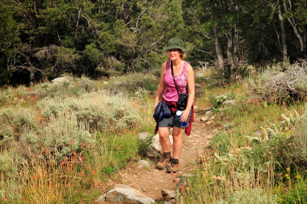
Emma heading back down the switchbacks on the West Rim Trail

We hiked back down then took the shuttle bus back to the Visitor Centre and freshened up in the RV. Refreshed we went back to the Zion Lodge for a great meal in the second storey restaurant.


We jumped back on the shuttle bus in the afternoon and rode to the Temple of Sinawava at the end of the line. We strolled part way up the Riverside Walk toward the Narrows. However, we were pretty much done so opted for a splash in the Virgin River.

North Fork of the Virgin River as it emerged from The Narrows

Emma wading in the Virgin River
After miles of hiking it was fun to wiggle our toes in the muddy bottom of the river.

Never one to tarry long we headed back to the RV and motored out of Zion National Park. At Cedar City, we stopped for the night.
July 19
Our next National Park was Big Basin in North Eastern Nevada. We headed north from Cedar City through lands of dry prairie mixed with sagebrush and desert cacti. At the higher elevations there were juniper trees.

The big basin area stretches from the Rocky Mountains on the east to the Sierra Nevadas on the west and from the Zion area on the south to the Oregon border on the North. All the waters draining into this area never reach the ocean. Instead they flow into the Great Salt Lake in Utah and evaporate.

It was a long drive and we arrived at Great Basin National Park in the afternoon. We found a campsite at Baker Creek and finished the day with a nice hike up the Baker Creek Trail.

Emma on the Baker Creek Trail

Prickly Pear Cacti


Emma on the Baker Creek Trail
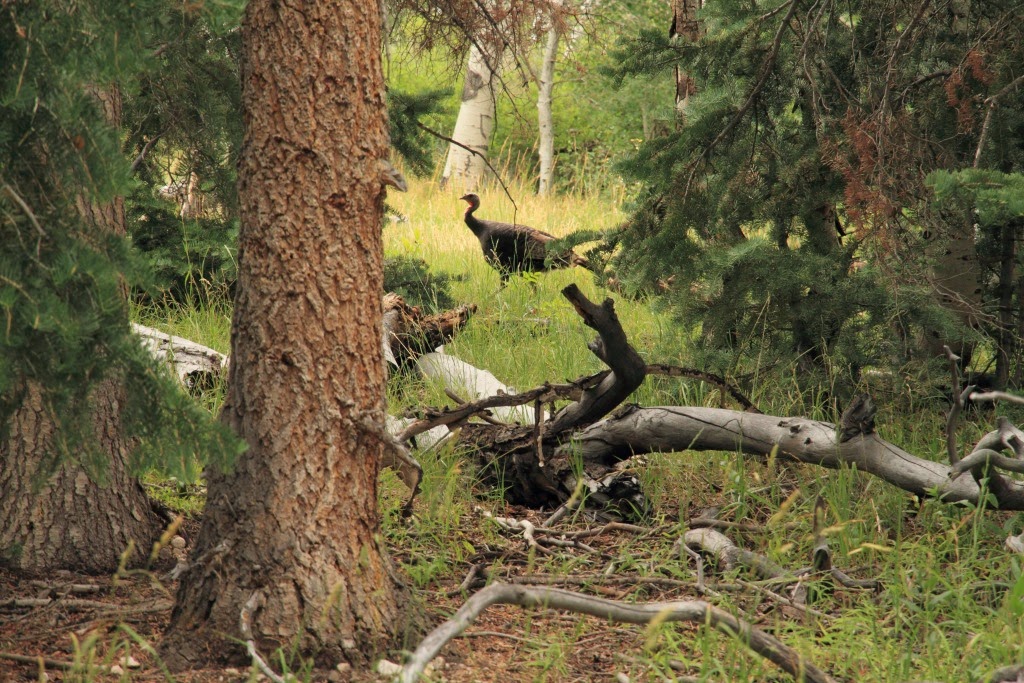
Wild Turkey
A family of wild turkeys crept though the grass as we hiked down the Baker Creek Trail
Yellow-bellied Sapsucker
July 20
We packed up in the early morning to make our 8:30 a.m. tour of the Lehman Caves.

Early Morning at the Baker Creek Campsite

Rufous Hummingbird - female

Lehman Cave in Great Basin National Park


Bacon Formation

Stalactites and Stalagmites

By mid morning, we were headed up to Wheeler Peak. Unfortunately, RVs are not allowed up the windy six mile road. No problem. We parked the RV at the base of the mountain and stuck out our thumbs. Six cars passed us then a family in a pickup truck stopped. There was lots of room in the back of the flatbed so we hopped in and motored up the mountain. When we got to end of the mountain road we hopped out. The driver said we were the best looking hitchhikers he has ever picked up.

Emma Checking out Wheeler Peak

Wheeler Peak - 3,983 m.
At 10,000 feet, we started up the Wheeler Peak Trail. The hike began through a forest of Trembling Aspens.

Wheeler Peak Trail

Great Basin Fritillary

View from the Wheeler Peak trail down into the surrounding Great Basin lands.

Wheeler Peak Trail
After the first kilometre, the trail opened up into a more open subalpine environment. 
We got a few kilometres up the Wheeler Peak trail when the clouds started to gather. The wind picked up and it started to rain. We did not want to get caught in a thunderstorm at the top of the mountain so we reversed ourselves and headed back down.

Wheeler Peak

It cleared up a bit so we decided to walk back down to our RV rather than hitchhike back. It was a very beautiful 5 mile walk through mountain forests. Thank goodness we were going down because it was a long circuitous trail.

Emma Descending the Lehman Creek Trail


Mule Deer

Emma on Lehman Creek Trail


Indian Paintbrush


Sulphur Buckwheat

Lehman Creek
The descent down the slopes of Wheeler Peak ended at the Upper Lehman Creek Campground.

Our last view of Wheeler Peak from the west side of the mountain.
It was late afternoon when we left Great Basin National Park and headed west toward Eureka, Nevada.
Beautiful pix and a great help to us as we travel from Zion to Great Basin in later Summer 2020
ReplyDeleteThank you,
Tom