After visiting Bryce Canyon, we decided to go to Cedar Breaks National Monument. Our initial plan was to go to Zion National Park next but the RV air conditioner is not working and we would have to descend a few thousand feet to get to Zion. Instead, we decided to climb from 8,000 feet to 10,000 feet and go to Cedar Breaks.

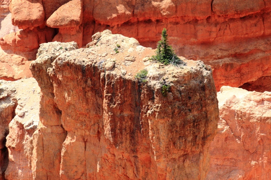
Last view of the Bryce Canyon area

On exiting Bryce we immediately traveled through the aptly named Red Canyon.
We completed our drive along Highway 12 and started ascending to 10,000 as we followed Highway 143. On the map, the distance from Bryce to Cedar Breaks is not far. However, on this windy mountain road it took us several hours to get to out destination.

This Red-tailed Hawk greeted us as we entered the Cedar Breaks National Monument
A short walk from the road provided a great panoramic view of the half mile deep Cedar Breaks amphitheatre.

Chessman Ridge Overlook

At the quaint Visitor Centre, we got directions to the nearby campground.

Visitor Centre - Cedar Breaks National Monument
Immediately outside the Visitor Centre was a spectacular view of the Cedar Breaks Amphitheatre.


View of the Amphitheatre from the Visitor Centre

After scoping out the campground, we capped off the day by doubling back to the Alpine Pond Trail and completing the 2 mile hike through the upper meadows of the park.


Alpine Meadow - Cedar Breaks National Monument
August 21
We spend a quiet night in the mostly empty campground. In the morning, I woke up with a splitting headache. That is quite unusual for me and I think it had something to do with altitude. I had never slept above 10,000 feet before.
Birds were all around the RV when we opened the curtains: White-crowned Sparrow, Mountain Chickadees, Chipping Sparrows and Yellow-rumped Warblers were present foraging in large numbers.

Northern Flicker

White-crowned Sparrow - Immature

We had one final look from a Cedar Breaks viewpoint before leaving the park.


Cedar Breaks is at the extreme western edge of the Colorado Plateau and is also one of its highest sections. We descended rapidly to Cedar City and the plains below the monument. After dropping several thousand feet I started to feel much better and my headache disappeared.
We had reached the western limits for our current trip and started to head back toward Dallas via Rocky Mountain National Park. We drove all day along Interstate 15 and 70. The day was hot and the terrain bone dry and rocky.

San Rafael Reef
The San Rafael Reef is a 30 mile long jagged mountain ridge that was not penetrated until 1967 when the I-70 forged a route through Wolfe Canyon.

Wolfe Canyon
By nightfall we made it back to Grand Junction, Colorado. We didn't get much exercise this day but enjoyed the mental and physical recovery time after what we had done and seen in the past few days.
August 22
The day started out hot as we drove through open prairie. As the elevation climbed we followed the Colorado River into the Rocky Mountains.
We stopped briefly at the town of Parachute and read about the 1904 train robbery and death of Harry Logan (Kid Curry). I had been reading about Butch Cassidy and his Wild Bunch as we traveled through Utah and Colorado. Kid Curry was the last of Bunch and his demise marked the end of the lawless times in the wild west. The country was not as wild and open as it once was as trains, roads, telegraph lines and political organization ended the days of hit and run train robberies.
As we climbing into the Rockies, the day became misty and rainy. We drove through the town of Vail, crested Vail Pass at 10,603 feet and sailed past Copper Mountain. At Silverthorne, we headed up Highway 9 to Windy Gap.

Colorado River near Windy Gap
Windy Gap is a water diversion and reservoir project which includes an nice wildlife refuge area. We enjoyed a pleasant hour watching and photographing some of the more cooperative subjects.

Brewer's Sparrow

Yellow Warbler

Cedar Waxwing
Leaving Windy Gap we drove around Lake Grandby, Shadow Mountain Lake and Grand Lake. After days of hot, dry, rocky terrain it was a pleasant change to be in lush green water filled valleys. As dusk approached, we headed into the west entrance to Rocky Mountain National Park.


Just inside the park we encountered a herd of elk that were trying to cross the road. A few elk had already crossed the road when the rest of the herd spooked and stampeded back into the forest.
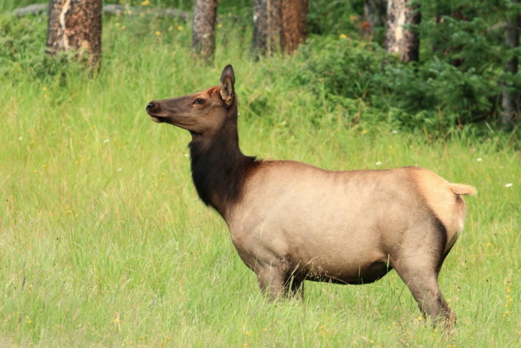
Elk


At dusk, we stopped at the Timber Creek Campground.
August 23
It was a beautiful morning as we followed the headwaters of the Colorado River up into the Rocky Mountains.


Moose

The Trail Ridge Road started to earn its name as the windy road got progressively steeper as we ascended from the Timber Line Campground at 8,500 to the Alpine Visitor Centre at 11,790 feet.

The Views Were Magnificent


Alpine Visitor Centre

Golden-mantled Ground Squirrel
A friendly ground squirrel was panhandling as people approached the Visitor Centre.


From the Alpine Visitor Centre, we decided to hike along the Ute Trail.


We didn't get far before a Yellow-bellied Marmon decided to check us out and see if Emma had any snacks.
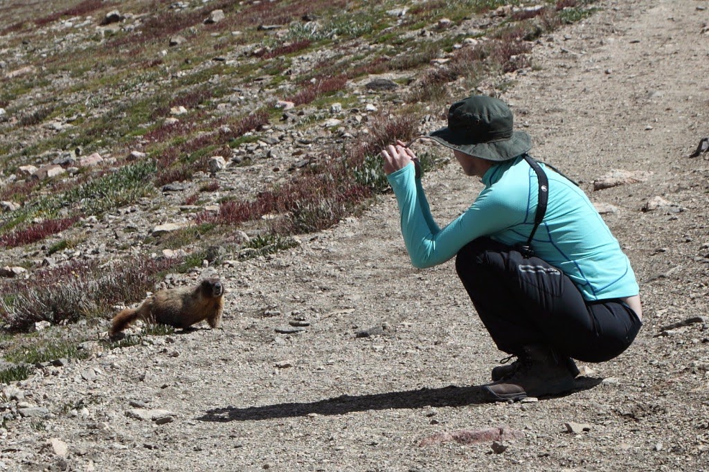

Yellow-bellied Marmon


The Ute trail is relatively level as you start at an altitude 11,790 feet and walk along the side of the mountain.

Even though the trail was relatively level we sauntered along so as not to get exhausted at this altitude. Well, I sauntered. As usual Emma started out at her usual brisk trot.


In short order, Emma was powering her way through the beautiful alpine meadows.

I continued to document the experience and waited for the altitude to slow down my energetic honey.

You feel on top of the world as you wander through sunlight alpine meadows.


Forest Canyon
We followed Ute Trail until we got a scenic view down Forest Canyon. This was a perfect spot to eat lunch and enjoy the view.


We retraced our steps back up the Ute Trail and continued driving along the Trail Ridge Road.
At 12,183 we reached the highpoint of our ascent and the road leveled off as we arrived at the Tundra Communities Trail head.

The trail is only 1.1 miles round trip but it takes your breath away quickly as you are hiking at over 12,000 feet. At this altitude, you are getting 35% less oxygen than at sea level so we took several breaks to enjoy this novel ecosystem.

Emma Beside Mushroom Rock
There were several Yellow-bellied Marmots scurrying about the rocks and boulders. With only 40 frost free days up here they need to forage while the food is available.


Marmot in the Tundra


A Red-tailed Hawk cruised low over the tundra and the marmots disappeared for a while.


Elevation 12,319 feet
Emma and Jim beside the Toll Memorial at the end of the Tundra Communities Trail.


We retraced our steps back along this beautiful alpine walk.

It was time to saddle up and start our descent from this high, austre, beautiful place into the eastern valley below.


The Rim Trail Road down the east side of the mountain was every bit as windy and precipitous as the west side. No guard rails and the thousand foot drops made for an exciting descent. A couple of times it felt like we were going to drive off the road and into mid-air. It was either negotiate the hair pin turns or fly off into space. Definitely, one of the most breathtaking roads were have ever been on.


Long's Peak - 14,259 ft.
When we made it to the valley below we took a breather to relax, recover and admire the surrounding mountains.

We hustled onward to the Moraine Park Campground but when we got there it
was full. Worse yet, there was a major cycling race the next day and
getting in or out of this national park would be problematic. We had little choice but to leave the park to find a campground.
The town of Estes Park is immediately adjacent to the east entrance of Rocky Mountain National Park. The town reminded me of Banff except it is smaller and compressed into a tight valley.
We followed Highway 34 toward Loveland. This road follows the Thompson River down a very steep and narrow gorge. It was very scenic but I had had enough of tricky windy roads for one day.
At Loveland, we got the last camping spot available. Wow, what a day!
No comments:
Post a Comment